1964 Alaska Earthquake
1964 Alaska Earthquake
The great Alaska earthquake occurred on March 27, 1964 at 5:36 pm. It was the second largest earthquake of the 20th Century. The earthquake's magnitude was 9.2 on the moment magnitude scale.
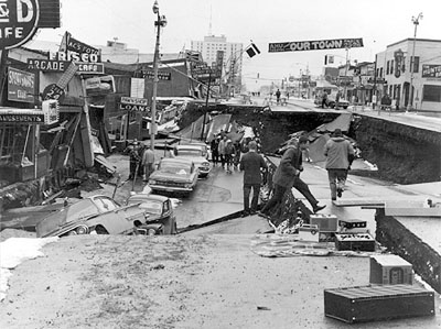
Downtown Anchorage after the earthquake USGS
Epicenter was in Prince William Sound
The Alaska earthquake epicenter was in Prince William Sound a region in Alaska approximately 120 km east of Anchorage. It was the second largest earthquake of the 20th Century. Very few people lived in the area and it happened on Good Friday, a holiday in Alaska, after the schools were closed and most people had gone home.
Megathrust earthquake in Alaska
The Pacific Plate in this region is moving to the northwest at about 5 to 7 km per year relative to the North American Plate. The plates became locked and pressure built up. The land crumpled as the pressure built raising some areas depressing other parts of the land.
Latouch and Montague Islands
Latouche Island moved 18 meters to the southeast when the rocks fractured. Montague Island was uplifted between 4 and 9 meters. The town of Portage dropped down approximately 9 meters and was abandoned after the earthquake.
Over 100,000 square miles of land was effected by the earthquake. The Pacific plate moved an average 9 meters beneath the North American plate.
Tsunami destruction
It is estimated that 131 people killed during the earthquake. Only 9 people were killed by the earthquake itself from falling structures etc. Most of the 131 people who died during the earthquake were killed by tsunamis.
Most of the people killed by the tsunamis lived in Alaska. It has estimated that 106 people died when landslides and ocean floor generated tsunamis swept ashore destroying villages and killing people.
More Earthquakes Links
Primary Waves Find out about primary waves which are the first earthquake waves to reach reporting stations.
Mercalli Scale Find out about the Mercalli scale that measures the intensity of an earthquake rather than its magnitude.
Earthquake Zones Find out more about earthquake zones that outline tectonic plate boundaries where plates are coming together, moving apart and slipping past each other.
1960 Chile Earthquake The 1960 Chile earthquake was the largest of the 20th Century. Find out what causes this great earthquake.
Earthquake Epicenter Find out where earthquake epicenters are located and how they are determined on this webpage.
Alaska Earthquake The Great Alaskan Earthquake was the second largest earthquake of the 20th Century. Find out about the landslides and tsunamis generated during the earthquake.
Earthquake Facts Find out about the discoveries that have been made by scientists using earthquake waves including layers of the Earth and outlining tectonic plates.
Home Kids Earth Science links to all the categories on our website.
KIDS FUN SCIENCE BOOKSTORE
 |
 |
Check out Myrna Martin's award winning textbooks, e-books, videos and rock sets. The Kids Fun Science Bookstore covers a wide range of earth science topics. Click here to browse.
Sign up to our monthly newsletter and receive our FREE eBook containing 3 fun activities that don’t appear in any of our other books!
The Kids Fun Science monthly newsletter will include the following: current events, weird and fantastic facts, a question of the month, science trivia and the latest new content from our website.
We respect your privacy and you can be assured that we will never share your email address or use it for any other purpose than to send you our newsletter.


